


Silar Bald
Field Notes ed XVI: backpacking and photographing Silar Bald in the Nantahala National Forest in Sept 2021

Welcome to this week’s Field Notes!
I went on a solo overnight backpacking trip to Silar Bald in Western North Carolina on September 25-26, 2021. Although I backpacked extensively as a teenager and into my early 20’s, this was the first trip I had done in many years beyond car camping with my family. Also, this was the first trip in which I combined backpacking with photography. There was a huge learning curve along with the experience of carrying and using the additional equipment on the trail.
Until recently, this image is what I considered the best photo that I came away with on this trip. For this post I revisited those photos and processed some that I hadn’t considered 2 years ago. You’ll find them below.

I wrote the following after returning home from the trip. Here, I have re-formatted it with some minimal editing and re-writing.
Silar Bald
After my last day trip, I came to the realization that a better option for photography trips would be overnight excursions. This would provide me time during the first day to drive to a location and hike in to the destination in time to catch the sunset. Then, I would already be at the location to photograph the sunrise. Also, not having to drive there and back in one day might allow me to expand my boundaries a bit. With this in mind, I had this weekend in September as a rare uncommitted opportunity. My family did not want to go with me, but supported me and encouraged me to go.
I camped and backpacked quite a bit when I was younger. I went on many solo backpacking trips, sometimes fueled by youthful ignorance of the potential dangers involved. I did have some close calls, but survived unscathed, and learned volumes from the experiences. As an adult, I have kept the interest in backpacking, even as the opportunities to do so have dwindled. For years now, all of my efforts and gear choices have gone towards introducing my children to camping and the outdoors. We’ve had some unforgettable adventures as a family. However, having to bring a shelter for 3 along with gear and supplies for myself and 2 kids who can’t carry much dictates the style of camping and locations available.
For this solo overnight trip I had all of the gear that I would need. The tricky part was the shelter. For camping with the kids, my go-to tent has been the (now out of business) Golite Shangri-La. I am a believer in the teepee style tent for its simplicity and livable space. But, this tent was much too large to bring as a solo shelter. My only other option was a bivy style tent, so old that I cannot remember who made it or where I got it, but still in serviceable condition. Its a simple design- a hoop over the head and over the foot, with stakes at the ends and a few in the middle. I used it on a few trips a couple of decades ago and, from what I remember, it functioned in decent weather conditions but was less than ideal. For this trip, it would have to do.
Knowing that I wanted to capture sunset and sunrise images, I searched for potential locations. The southern Appalachian Mountains are known for their balds. These summits are covered in native grasses or low shrubbery, but exist at elevations that still should support forest. There are several theories about their origins, such as lightning sparked fires or cattle grazing. One thing is certain- they are an essential part of the character of this land, and would provide exceptional vistas for landscape photography. I discovered one such location named Silar Bald, in the Nantahala National Forest of Western North Carolina. It is located close by the Appalachian Trail, and the AT has a Silar Bald shelter in the area. It should not be confused with Silars Bald in the Great Smoky Mountain National Park. Silar Bald is a reasonable drive from my location and the hike, at under 2 miles, a nice way to ease back in to solo backpacking.
I left town at noon. The drive there was uneventful and I arrived at Wayah Gap at 14:40. A description I found on-line indicated that the parking area and start of the trail was at the picnic area at Wayah Gap. However, I saw no signs indicating where the picnic area was located. Instead, I saw a few cars parked on the side of the roadway and I found a spot to do the same.
The route starts along the Appalachian Trail, white blazed and easy to follow. It climbs gently through the forest to a junction at Snowbird Gap. Along the way I met other hikers who told me the Silar Bald shelter was worth a visit. When I mentioned that I’d like to see it, as well as stay at the bald, they let me know that I could “probably” do both. I didn’t understand what that meant at the time.
Snowbird Gap opens up into a clearing. A sign indicates the trail to Silar Bald in one direction and to the shelter in the other. I started towards the shelter. The trail seemed to be dropping straight down off of the mountain. I continued to follow it, thinking that I would see the shelter at every turn. I never reached it. Not knowing how far the shelter was, I eventually decided to cut my losses. I not only had to climb my way back to Snowbird Gap, but then still had the unknown climb to the bald. I still think that shelter was just around that next turn!
On the climb to Silar Bald I passed a guy flying a drone. I understand the rising appeal of drones and the images that can be gotten, but the mechanical buzzing that can be heard from far away is something I hope to escape by coming to wilderness areas. To me, they are a frustrating intrusion and I don’t plan on ever using one in the back country. Fortunately, this drone flyer packed up and left.
I passed a few more hikers leaving the area. I arrived at the summit just after 16:00 and was the only person there. There were several potential camping spots. I picked one and began setting up. I had been worried about crowds on a weekend in the fall. Sure enough, another very talkative backpacker arrived and immediately proclaimed that it would be crowded here this night. Later, his 2 friends arrived and then another solo backpacker. Overall, they were very friendly, although the one fellow poured a constant stream of words with hardly a break between them.
This location was incredible and the views spectacular! I tried to determine the exact location of sunset and sunrise. It seemed like trees would block the view in those exact directions, but I had no doubt about catching stunning images.

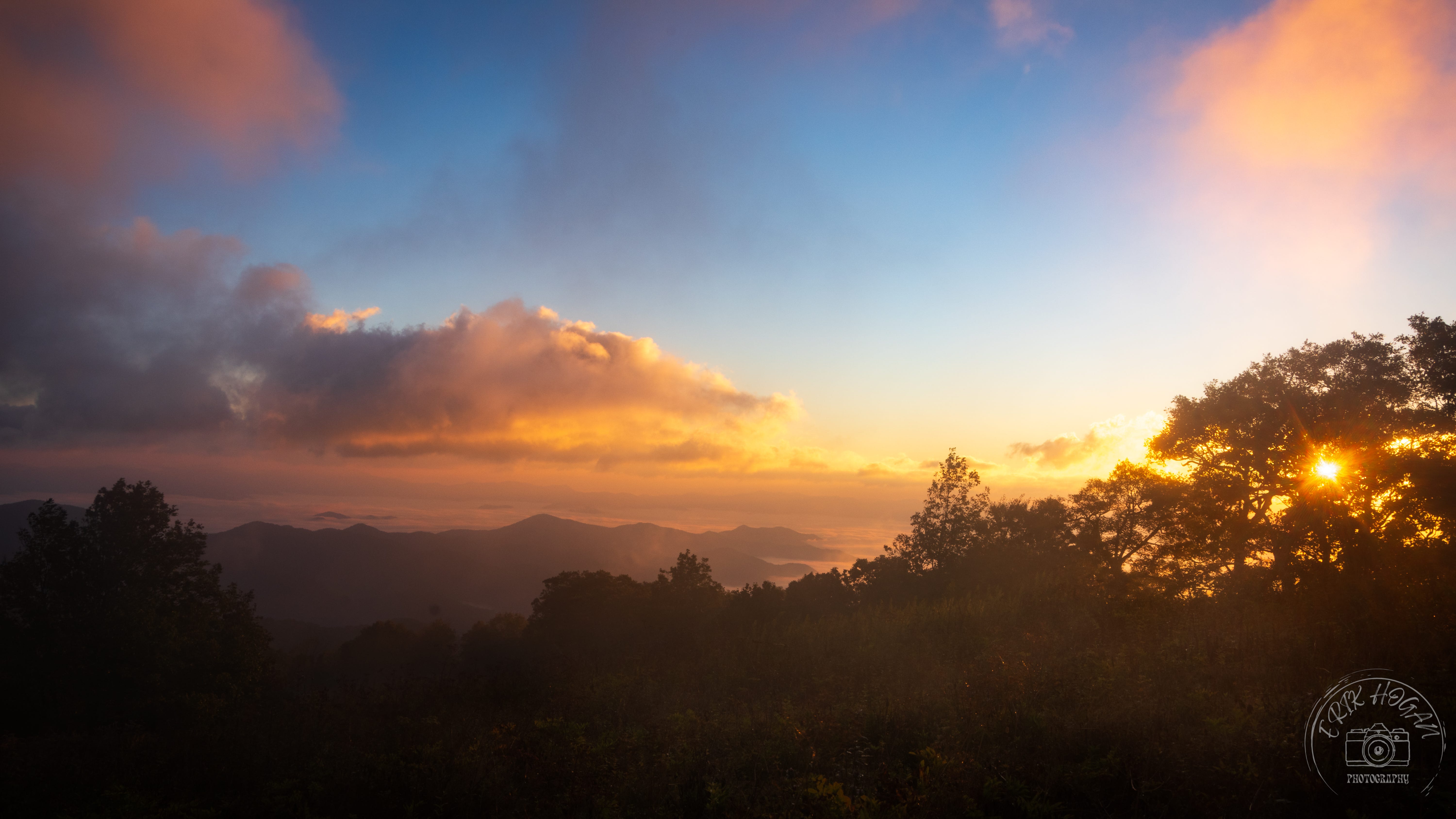
I had taken photos along the way and my first camera battery died before reaching the summit. I had taken care to put a fresh battery in the camera for the trip. The only explanation could be that I put in a battery that was not charged. I still had 2 spare batteries and these were fully charged. Even though the cloud cover was minimal, the sunset was spectacular. I was caught in the desire to make the most of the moment and rushed to get multiple exposures at multiple locations and perspectives. I was surprised to find that some of the most impressive colors actually came after the sun had set.

By this time my second battery was beginning to run low. Maybe the cold was making them drain faster than normal. With only one more, I worried about it draining overnight and not having enough juice for the sunrise. Well after the sun set the stars began to gleam. I haven’t learned about astrophotography, but I was definitely interested in experimenting. I tried a couple of exposures with battery 2 but, when these didn’t turn out, I opted to call it quits for the night. I also opted to keep battery 3 in my pocket, as warm as possible til the morning.
The group of 3 other backpackers set up their tents directly on the rocks at the summit. This alone wasn’t a problem and they were not uncomfortably close. However, the rocks were the only place that I would have been able to sit comfortably, and I did not bring a camp chair.
The tent was very cramped. I’m not very tall, so length-wise it was fine. But, as a bivy style tent, it wasn’t even tall enough to sit up inside of it. I didn’t want to leave my pack outside in the elements, so I crammed it in along side of me. But, after inching my way in and zipping up, it was a decent place to sleep. Gusty winds jostled the tent at about 03:30 and woke me. I wormed my way out of the tent and saw clouds racing above, streaking past the moon. The tent held up well, but the middle sagged enough that in the morning it was in contact with my sleeping bag. Condensation on the inside made my bag damp, but not terribly so.
The weather that moved in overnight stayed and the morning was very windy. I was up in the pre-dawn, looking at fast moving cloud cover and frantic trees. The clouds broke, though, and the sunrise was incredible. Again I raced to get different exposures and different scenes. By this time the other backpackers were supporting my efforts and calling out different views they thought would make good photos. My pocket battery held up through the night and I had power for all of my attempts. However, I hadn’t photographed in conditions this challenging before. Low light generally means longer exposures. Longer exposures with moving trees and clouds will leave the images blurry, not to mention the wind shaking the camera itself. My attempts at focus stacking or exposure blending likely wouldn’t turn out due to this. I did my best and would have to wait until post processing to find out.
After the sun was fully risen I packed and returned to Wayah Gap. It was near here that I took a side trail off of the AT and discovered the picnic and parking area. It wouldn’t be difficult to find, but I would have had to turn on an unmarked dirt road to get there.
The return home was uneventful. It was after getting home that I realized my knee was stiff and when I inspected it found that it was substantially swollen. This is the knee in which I tore my ACL a couple of years ago and required surgery and more than 6 months of rehab. Nothing during this trip made me think I had re-injured it. It did not hurt, but the swelling stuck around for almost a week. In thinking back about the trip, it may have been the steep downhill walking with a loaded pack that caused the issue.
RESULTS
The mission was a solid success. I validated the plan of an overnight trip to capture sunset and sunrise at locations that I could not make it to in the context of a day trip. The sunset images I captured were very pleasing. While I could not use the sunrise images as focus stacks or exposure blending because of wind and motion, I still came away with some striking photos.
Camp coffee was a success.
I was able to pick up with backpacking, even though I had not done it seriously in many years. The physical effort was moderate, which validated my current strength and fitness training for this type of adventure. My previously injured knee did swell afterwards, and I will need to think of ways to mitigate this in future trips.
The old bivy tent I had was put to the test. It functioned and held up to the elements of strong winds, cold, and moisture, enough to allow me to survive the trip and consider more trips before upgrading. However, it was very cramped and seriously lacking in terms of livability.
Thanks for reading. It has been interesting for me to see how my writing and photography have changed over the past couple of years. Hopefully it has been an engaging read for you, too!
I have more trips in the works, which means more photography and more Field Notes. I update the galleries from time to time, so keep checking back!
If you are enjoying these posts, subscribe and help spread the word!
Interested in helping? Click here-
I've tried it on a few occasions now. I got a few Milky Way shots from Pickens Nose, NC last September. All of my trips this year have had unsuitable conditions, but I hope to try again this coming week!
Have you gotten into Astrophotography yet?